Always private
DuckDuckGo never tracks your searches.
Learn More
You can hide this reminder in Search Settings
All regions
Argentina
Australia
Austria
Belgium (fr)
Belgium (nl)
Brazil
Bulgaria
Canada (en)
Canada (fr)
Catalonia
Chile
China
Colombia
Croatia
Czech Republic
Denmark
Estonia
Finland
France
Germany
Greece
Hong Kong
Hungary
Iceland
India (en)
Indonesia (en)
Ireland
Israel (en)
Italy
Japan
Korea
Latvia
Lithuania
Malaysia (en)
Mexico
Netherlands
New Zealand
Norway
Pakistan (en)
Peru
Philippines (en)
Poland
Portugal
Romania
Russia
Saudi Arabia
Singapore
Slovakia
Slovenia
South Africa
Spain (ca)
Spain (es)
Sweden
Switzerland (de)
Switzerland (fr)
Taiwan
Thailand (en)
Turkey
Ukraine
United Kingdom
US (English)
US (Spanish)
Vietnam (en)
Safe search: moderate
Strict
Moderate
Off
Any time
Any time
Past day
Past week
Past month
Past year
  1. Was this helpful?
  2. Was this helpful?
  3. irelandmap.net

    The province got its name from the Connacht, a medieval ruling dynasty. It is located on the west of the island and consists of five counties. Connacht covers an area of 17,788 km2, and has a population of around 550 thousand, making it both the smallest and least populated province of Ireland.
    • Contact

      Please mention that you are writing about Ireland Map. If you have question about map please contact openstreetmap. Also please note we are not allowed to resell or print maps we use on this website so we can't offer you that. Search for: SELECT A CITY FROM THE LIST TO SEE DETAILED MAP. Republic of Ireland. Athlone; Balbriggan; Bray; Carlow;

    • Bray

      Bray, Leinster, Ireland. Bray is an Irish coastal town located 20 kilometres south of Dublin in the province of Leinster. It has a population of 32,600. Due to its proximity to Dublin, it became a resort town for day-trippers from the capital. The town is filled with hotels, guesthouses, shops and restaurants.

    • Navan

      Navan is an Irish town in the province of Leinster. It lies at the confluence of the River Boyne and Blackwater. It has a population of 30,173 inhabitants. Navan is a town of Norman origin and is one the world's few towns that have palindromic names. Navan is surrounded by interesting sights, the most prominent being the Hill of Tara, one of ...

    • Provinces

      Since the early 17th century, there have been four Provinces of Ireland as an island: Connacht, Leinster, Munster, and Ulster. Today they only function as historical and cultural entities. Ulster province map - Road map with towns
  4. en.wikipedia.org

    There are four provinces of Ireland: Connacht, Leinster, Munster and Ulster.The Irish word for this territorial division, cúige, meaning "fifth part", suggests that there were once five, and at times Meath has been considered to be the fifth province. In the medieval period, however, there were often more than five. The number of provinces and their delimitation fluctuated until 1610, when ...
  5. britannica.com

    Jan 14, 2025Connaught, one of the five ancient kingdoms or provinces of Ireland, lying in the western and northwestern areas of the island. Its eastern boundary is the middle course of the River Shannon. Connaught is the poorest part of the Irish republic and comprises the modern counties of Mayo, Sligo,
    Author:The Editors of Encyclopaedia Britannica
  6. wanderlog.com

    What's on this map. We've made the ultimate tourist map of Province of Connacht, Ireland for travelers! Check out the Province of Connacht's top things to do, attractions, restaurants, and major transportation hubs all in one interactive map.
  7. irishgeopol.org

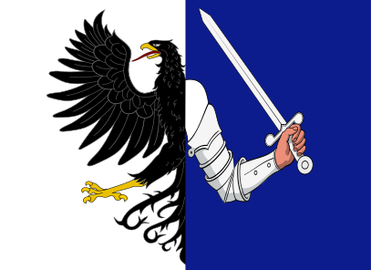
    Map of Connaught, Ireland. Map of Connaught showing its counties. Map of Connaught province shown on the island of Ireland. Léarscáil Connachta a thaispeántar ar oileán na hÉireann. Connachta. Connaught flag badge with text. Map of Connaught shown in red as one unit. Commercial use of the images in this site is not permitted, nor is use in ...
  8. tripsavvy.com

    County Galway . Galway (in Irish Gaillimh) is maybe the most well-known County in the Province of Connacht, especially Galway City, and the Connemara region.The county stretches over 2,374 square miles and has (according to the 2016 census) 258,058 inhabitants. Compared to 1991 this denotes an increase of 40%, one of the fastest rates of growth in Ireland.
  9. Can’t find what you’re looking for?

    Help us improve DuckDuckGo searches with your feedback

  1. More Images

    Connacht

    Province in Ireland

    Connacht or Connaught, is one of the four provinces of Ireland, in the west of Ireland. Until the ninth century it consisted of several independent major Gaelic kingdoms. Between the reigns of Conchobar mac Taidg Mór and his descendant, Aedh mac Ruaidri Ó Conchobair, it became a kingdom under the rule of the Uí Briúin Aí dynasty, whose ruling sept adopted the surname Ua Conchobair. At its greatest extent, it incorporated the often independent Kingdom of Breifne, as well as vassalage from the lordships of western Mide and west Leinster. Two of its greatest kings, Tairrdelbach Ua Conchobair and his son Ruaidri Ua Conchobair greatly expanded the kingdom's dominance, so much so that both became High King of Ireland. The Kingdom of Connacht collapsed in the 1230s because of civil war within the royal dynasty, which enabled widespread Hiberno-Norman settlement under Richard Mór de Burgh, 1st Baron of Connaught, and his successors. The Norman colony in Connacht shrank from c. Wikipedia

    StateIreland
    CountiesGalway, Leitrim, Mayo, Roscommon, Sligo
    Teachtaí Dála6 Independent TDs, 5 Fine Gael TDs, 4 Fianna Fáil TDs, 4 Sinn Féin TDs
    Was this helpful?
Custom date rangeX