Always private
DuckDuckGo never tracks your searches.
Learn More
You can hide this reminder in Search Settings
All regions
Argentina
Australia
Austria
Belgium (fr)
Belgium (nl)
Brazil
Bulgaria
Canada (en)
Canada (fr)
Catalonia
Chile
China
Colombia
Croatia
Czech Republic
Denmark
Estonia
Finland
France
Germany
Greece
Hong Kong
Hungary
Iceland
India (en)
Indonesia (en)
Ireland
Israel (en)
Italy
Japan
Korea
Latvia
Lithuania
Malaysia (en)
Mexico
Netherlands
New Zealand
Norway
Pakistan (en)
Peru
Philippines (en)
Poland
Portugal
Romania
Russia
Saudi Arabia
Singapore
Slovakia
Slovenia
South Africa
Spain (ca)
Spain (es)
Sweden
Switzerland (de)
Switzerland (fr)
Taiwan
Thailand (en)
Turkey
Ukraine
United Kingdom
US (English)
US (Spanish)
Vietnam (en)
Safe search: moderate
Strict
Moderate
Off
Any time
Any time
Past day
Past week
Past month
Past year
  1. More Images

    Kīlauea

    Active volcano in Hawaii

    Kīlauea is an active shield volcano in the Hawaiian Islands. It is located along the southeastern shore of Hawaii Island. The volcano is between 210,000 and 280,000 years old and grew above sea level about 100,000 years ago. Since the islands were settled, it has been the most active of the five volcanoes that together form the island and among the most active volcanoes on Earth. The most recent eruption began in December 2024. Kīlauea is the second-youngest product of the Hawaiian hotspot and the current eruptive center of the Hawaiian–Emperor seamount chain. Because it lacks topographic prominence and its activities historically coincided with those of Mauna Loa, Kīlauea was once thought to be a satellite of its much larger neighbor. Kīlauea has a large, fairly recently formed caldera at its summit and two active rift zones, one extending 125 km east and the other 35 km west. An active fault of unknown depth moves vertically an average of 2 to 20 mm per year. Wikipedia

    Was this helpful?
  2. Summary. Topographically Kīlauea appears as only a bulge on the southeastern flank of Mauna Loa, and so for many years Kīlauea was thought to be a mere satellite of its giant neighbor, not a separate volcano.
    • Volcano Updates

      HAWAIIAN VOLCANO OBSERVATORY DAILY UPDATE U.S. Geological Survey Sunday, January 5, 2025, 8:46 AM HST (Sunday, January 5, 2025, 18:46 UTC) KILAUEA (VNUM #332010) 19°25'16" N 155°17'13" W, Summit Elevation 4091 ft (1247 m)

    • Monitoring Data

      Above: The blue line shows the radial tilt at station UWD near Uēkahuna, on the western rim of Kīlauea's summit caldera.The green line is a radial tilt at station POC on the north rim of Pu'u'ō'ō cone on the middle East Rift Zone of Kīlauea. These are recorded by continuously operating electronic tiltmeters.

    • Multimedia

      Pieces of lava (called tephra because they travel through the air before being deposited on the ground) blanket the crater rim downwind of the erupting vents in Kīlauea summit caldera (Kaluapele).

    • Webcams

      Webcams show current conditions on Kīlauea Volcano. Direct links to all individual Kīlauea webcams. Kīlauea volcano, Summit

    • Maps

      This thermal map shows lava flows covering the floor of Halemaʻumaʻu crater at the summit of Kīlauea. Fountaining was active in the southwest portion of the caldera, with flows extending east onto the downdropped block.

    • Photos & Videos

      The Kīlauea Photo and Video Chronology provides visual updates of eruptive activity, field work, and more.
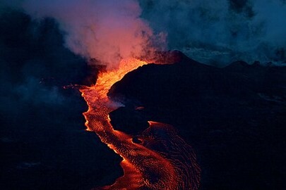
  3. en.wikipedia.org

    Kīlauea is a Hawaiian word that means "spewing" or "much spreading", referring to its frequent outpouring of lava.Its earliest lavas date back to its submarine preshield stage.Samples were recovered by remotely operated underwater vehicles; samples of other flows were recovered as core samples.Lavas younger than 1,000 years old cover 90 percent of the volcano's surface.
  4. earthobservatory.nasa.gov

    Dec 30, 2024On December 23, 2024, after three months of quiet, Kīlauea began spewing fountains of lava. The lava poured from a line of fissures near the southwest wall of Halema'uma'u crater, which lies within Kaluapele—the Hawaiian volcano's summit caldera. The ongoing eruption is the sixth to occur within this caldera since 2020.
  5. landsat.visibleearth.nasa.gov

    On December 23, 2024, after three months of quiet, Kīlauea began spewing fountains of lava. The lava poured from a line of fissures near the southwest wall of Halema'uma'u crater, which lies within Kaluapele—the Hawaiian volcano's summit caldera. The ongoing eruption is the sixth to occur within this caldera since 2020.
  6. volcano.si.edu

    Kīlauea is the southeastern-most volcano in Hawaii and overlaps the E flank of the Mauna Loa shield volcano. Its East Rift Zone (ERZ) has been intermittently active for at least 2,000 years. An extended eruption period began in January 1983 and was characterized by open lava lakes and lava flows from the summit caldera and the East Rift Zone.
  7. volcano.si.edu

    Kīlauea is the southeastern-most volcano in Hawaii and overlaps the E flank of the Mauna Loa shield volcano. Its East Rift Zone (ERZ) has been intermittently active for at least 2,000 years. An extended eruption period began in January 1983 and was characterized by open lava lakes and lava flows from the summit caldera and the East Rift Zone.
  8. volcano.si.edu

    Kīlauea is the southeastern-most volcano in Hawaii and overlaps the E flank of the Mauna Loa shield volcano. It's East Rift Zone (ERZ) has been intermittently active for at least 2,000 years; an extended eruption period began in January 1983 and was characterized by open lava lakes and lava flows from the summit caldera and the East Rift Zone.
  9. Can’t find what you’re looking for?

    Help us improve DuckDuckGo searches with your feedback

Custom date rangeX